Gavin sent me a nice message yesterday with the curious title, "Stay Dry". Then I remembered that he is an American these days and one should not take these things literally. I interpreted it as a version of that "Stay Safe" phrase they love to use. Naturally it is not possible to literally Stay Dry in Yorkshire. It is always raining outside, and inside the new houses leak because they are new, and the old ones leak because they are old. However, recently, it has been quite a bit wetter than is normal! Even wetter than normal wet flood weather!! Apparently the water has invaded the homes of more than 5000 people in this part of the country, and the town where I went to ("high") school is now a Zombie Apocalypse. To be honest it never has been that cheery a place...
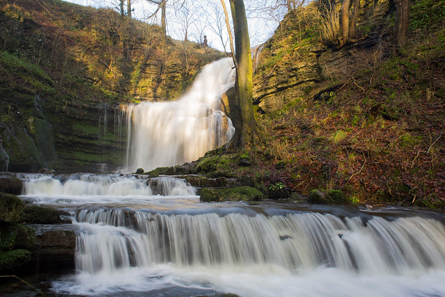
I'm not one for disaster photography. Today the sun came out for a moment, so I cycled up to the local waterfall, Scaleber Force, which was in great form.
I suppose I missed the best one - apparently, for the first time evs, the waterfall has started flowing over Malham Cove. That's just a few miles away from Scaleber, on the other side of the watershed.
Meanwhile, James is practising his lime mortaring on some of the places where leaks sprung in our house. We avoided buying one of the newish houses nearby that, although favourably priced, seemed to me to be rather close to the flood plain. Ours is over 100 years old, but that alone doesn't offer much in the way of guarantees for dry toes if we are to have frequent 100 year events.
Meanwhile, James is practising his lime mortaring on some of the places where leaks sprung in our house. We avoided buying one of the newish houses nearby that, although favourably priced, seemed to me to be rather close to the flood plain. Ours is over 100 years old, but that alone doesn't offer much in the way of guarantees for dry toes if we are to have frequent 100 year events.
Posted By Blogger from jules' pics.
10 comments:
But then they won't be 100-year events any more, will they, so that should be fine. ;)
How far above the 100-year flood level are you?
About 50m vertical, so I think we are safe enough in that respect :-) There is a whopping flood plain in the valley bottom much enjoyed by hippos during the last interglacial, but it's a fair way down hill from here.
Of course if enough water pours down off the hillside then at some point it might prefer to take a short cut through our house rather than politely flowing past like it does presently.
Tsk. Obviously it is meaningless to shift the goal posts like that, and clearly I meant 100 year events for the climatology representative of the late 19th century when the place was built.
And I see that James has just answered the rest of wot I was going to say... :o
The satellite presentation of Desmond looked like an atmospheric river, and upon checking so it was (and I see that WP already has it as the new AR poster-storm, so it must be exceptionally photogenic). If indeed Britain is in for worse such in the future, it's instructive to consider the one really big one in the historical record (others on the same scale show up in sediments). Britain lacks the potential snow component, but the rain part alone would make Desmond look like he was wearing a tutu (sorry, couldn't resist).
While I'm on the subject, a few years back I was chatting with a USGS scientist here about the AR megastorm scenario they developed for emergency planning purposes. I had had a look at it and realized that it was just a shadow of the 1862-3 event. I asked him why and he said that the evacuation procedure they had worked up for a smaller event was all that was applicable to a big one; nothing else in the plans could be scaled up such that it wouldn't be overwhelmed. How nice.
Ironically, or not, moments after writing that I got whacked with the tail of the Pacific AR shown with Desmond in the WP article. It's sort of a weird, stunted AR that didn't succeed in unwrapping itself from the cyclonic low, from the looks of it due to the tropics having not provided enough moisture ("I'm no met" caveat applies), consequent to which it only rained for a couple hours here, although I understand things got quite wet enough up in BC. (Just to mention that despite much over-excitement the last few months, including from some scientists who ought to have known better, so far this El Nino has itself been something of a bust when it comes to drought-busting. Stationarity is dead, as Schellnhuber says.)
Somewhat on topic, Coumou and colleague at PIK have produced yet another paper ("press release) on the northern mid-lat weather extremes trend conundrum. At a first glance they draw some pretty strong conclusions. The don't do attribution, but seem to hint pretty strongly that that's their next step.
I mention that because I'm not at all clear how the trend they discuss should affect ARs. One would think reduce their frequency along with all the other storm types, but OTOH the really nasty ARs become such due to the stuck patterns that are becoming increasingly common.
I suppose Jennifer Francis must have somewhat mixed feelings about this, but PIK's decision to commit major resources to this topic probably made it inevitable that Coumou et al. would become the field leaders.
Getting wet again, I see.
Hmm, just saw some Beeb flood footage featuring your local alliterative tongue-twister watercourse. Hopefully not too bad in Settle.
We were away until today. Nothing much apparent on the trip home but our friends down in the valley might have been a bit damp.
Watching your incoming weather news ....
who names these storms?
They never name them "Mothra" or "Godzilla" ...
The naming is a new thing this year. There was a previous (unofficial) "Hurricane Bawbag" but the UKMO has refused to add that name to their official list.
Post a Comment