An image showing what happens when unregulated cattle and sheep barons get free reign to do what they want, which is to suck as much money out of the area as possible, never mind the state of the ecology when they are finished. Did you take this photo with that in mind or what?
(the captcha was repeatedly unreadable, the people in charge need to get some brains) 4th
guthrie: An image showing what happens when unregulated cattle and sheep barons get free reign to do what they want
Oh good grief, what silly prattle.
This part of Wyoming is semiarid land filled with spiny cactus, mesquite and tumble weed, with or without the "free reign of cattle and sheep", which if you're very lucky, you might actually spot one, BLM land or otherwise.
I wouldn't imagine it looks remarkably different now versus 200 years ago (except for the "free reign" of buffalo in those days instead of cattle or sheep).
+1 David "B" Benson's psychologist. Feeling his pain.
Carrick --- Mostly just antelope; buffalo need more grass than that part of Wyoming will support. Sheep are very hard on the grass; so much so that I doubt there are any there. That leaves cattle. Too many is also hard on the grass. Too few is hard on the cattleman's pocket book. The effect is that the ecology loses and the grasslands proceed towards the pictured semidesert.
BLM is entirely run by the cattlemen, for the cattlemen. You might care to learn about how this is legally accomplished.
As to BLM people, I think you are giving them short shrift here. I've visited their offices and see the type of people that work there. We work with them closely on experimental design, and they are very conscious of the potential impact our research may have on the land [The chief concern in case you're wondering is starting fires via the catalytic converter on the vehicle.
They are also often very concerned about resource management, alien species control, that sort of thing... I've seen them in action, and your one-dimenstional version of it is completely unrealistic and unfair (it reads like a blurb from Sierra Club).
Get out of the office and learn what's really going on in the world. My advice to you.
Hmm, looks like I'll have to explain, especially for Carrick who seems to want to take it personally.
The sign refers specifically to the history of the land as used for cattle and sheep, or rather, cattle or sheep. You see it is rather well documented that back in the 19th century there was a great deal of corruption and lawlessness in Wyoming, such that cattle barons regarded the public grasslands as theirs, and went out to kill shephers and sheep who were using it at the time.
Of course the big business then was also overgrazing the land, less through stupidity and more because they didn't know much about ecology etc then. Either way, a title of "commited to the land" seems historically to be a little iffy...
Fast forwards to 1947. The various acts and legislations designed to protect watersheds, thus preventing flooding, bad erosion and dust storms etc, were causing permits for numbers of sheep and/ or cattle to be cut. Now with the Forest Service using actual science, it all seems rather familiar to those of us who are following the climate change debate.
A congressman, Frank Barret of Wyoming, was in charge of one subcommitee which toured affected areas asking for input. Oddly enough, in his home state, in the town of Rawlins, the meeting was packed with stockmen and their bosses, who dominated the meeting. Even more oddly, the actual science and conservation people were held to very short speaking times at the end of the day, and beforehand had been accused of such heinous (but baseless) crimes of wanting to eliminate all livestock grazing from forersts. More of a smoke screen was put up with claims that the ranges were fine, nothing to worry about etc etc.
Of course from what CArrick says it seems that the above photo was taken of an area not used for ranching, but then you wonder why it mentions it so clearly? Also I meant no slur on the modern ranchers, since I don't know what they are doing. Information from "The western Paradox" by Bernard de Voto, which is a collection of his essays on conservation in the west. The situation should be familiar to everyone - one part of society trying to extract the maximum output from an area before a drought or such, which ends up increasing the damage when you do get a drought and leaving the actual people living there to carry the can. Oh, and obstruction using politicians and lies, that's an ooollldd, tactic.
Bureau of Logging and Mining is pretty much the same everywhere in the west. But lots and lots of WY is desert (or arid steppe). It has also been abused pretty badly, and the climate limits it's ability to recover.
I dunna why you think I take this personally guthrie and obviously I can read a sign.
That the sign says what it says, hardly proves your original assertion "An image showing what happens when unregulated cattle and sheep barons get free reign to do what they want"
In terms of economics, number one for the state is mining ($6 billion), number two is tourism ($2 billion), number three is agriculture ($1 billion) of which about $800 million is from cattle.
That puts them 14th in the nation in cattle production, less than 2% hardly on the map. As I said, pretty thin population to be trampling up that much soil (in comparison say to native populations of wild life).
If you wanted to point a finger to the real damage that the ranchers have caused it's shooting the wolves, which historically were responsible for keeping native herds of antelope, deer and elk in check.
Anyway people get to make any claims they want as long as nobody ever challenges them on it. Maybe that graceless on my part to challenge it, maybe not.
Rattus I'm quite familiar with the issues of land use (and abuse) and the time it takes for arid & semiarid land to recover, I'd suspect none of you guys do field work so you have no personal experience and everything you "know" is based on somebody's sensationalized account and probably would have to look up what a "cryptobiotic crust" in order to even know what it is, let alone its relationship to the land, soil conservation, and disturbance of the soil by hoofed creatures.
Anyway the recovery time is not centuries, even in areas with as little as 8" of rain per year, 20 to 30 years you can't even see an old road that should have been there on the map (until you stumble on it, even then you have to be looking, but not drivable).
It does recover, even in arid parts of NM that have suffered for lack of rainfall for a decade.
There's a spot on Kirtland AFB which really nicely illustrates this. In the middle of this spot, they frequently blow stuff up (lookup Chestnut range) and as you go away from it, it is less and less disturbed. By the time you're a km away, it looks pretty much like any land in the region, including stuff south of the fence bordering Kirtland with the Isleta Reservation (which borders the Chestnut range to the south).
I've a nice set of pictures that starts with the "ring" around one of the EOD (explosive ordinance disposal) sites, and moves away from it to the NW. By a km north all that remains besides a road is old bunkers left from WW II, and if you walk around this area, mostly the only artifacts you'll find are lines of thin bare wire lying on the ground (the insulation long ago flaking off).
We mostly deploy our equipment off base and on BLM land. I've been on USFS land too, and I can tell you at least in AZ, it is in much worse shape than the BLM land, because much of the USFS land is wooded and people are more likely to camp there. I was on the Mogollon Rim this summer, and the place I was at, was an absolute pig sty with all of the human litter, chopped up woods, cut-in ATV trails and what not.
You guys just *think* cattle are bad. Ironically (wrt to this thread) there was a cattle fence, and the side the cattle were on looked tons better than the side the humans were camping on.
Large numbers of cattle populated this country prior to the devastating storms of the 1880’s. Sheep were far more profitable than cattle and sheep herd began to multiply. However, the terrible winter of 1919 and predators took their toll on the sheep industry.
This land was heavily homesteaded when the federal government encouraged World War I veterans to populate the new west, offering 320 acres to anyone who asked. The climate proved too dry for even the dry land wheat that many settlers planted and they eventually sold out to livestock interests that remain dominant today. Because of arid conditions early ranchers developed many small reservoirs to capture whatever precipitation came from snow runoff or thunderstorms. It was not until the 150;s that electricity finally came to the area making possible the drilling of water wells.
Making a living in the early agriculture of this area of Wyoming meant being self reliant. Going to town was, at best, a once a month venture. According to one rancher whose father homesteaded in this area and who now operates over 60,000 acres of federal state and deeded lands, it was a fantastic way of life for his six children and wife, “but you have to be committed to the land”. These challenges and this commitment remain for today’s ranchers
Well I don't have an axe to grind here, but it is hard to imagine that this climate and landscape could be conducive to verdant pasture however well managed it was. Of course the dinosaurs tell a different story over geological time.
13 comments:
Going to Yellowstone?
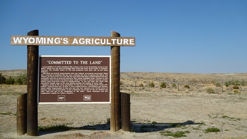
An image showing what happens when unregulated cattle and sheep barons get free reign to do what they want, which is to suck as much money out of the area as possible, never mind the state of the ecology when they are finished.
Did you take this photo with that in mind or what?
(the captcha was repeatedly unreadable, the people in charge need to get some brains) 4th
What guthrie said.
Except about the capcha.
guthrie: An image showing what happens when unregulated cattle and sheep barons get free reign to do what they want
Oh good grief, what silly prattle.
This part of Wyoming is semiarid land filled with spiny cactus, mesquite and tumble weed, with or without the "free reign of cattle and sheep", which if you're very lucky, you might actually spot one, BLM land or otherwise.
I wouldn't imagine it looks remarkably different now versus 200 years ago (except for the "free reign" of buffalo in those days instead of cattle or sheep).
+1 David "B" Benson's psychologist. Feeling his pain.
Carrick --- Mostly just antelope; buffalo need more grass than that part of Wyoming will support. Sheep are very hard on the grass; so much so that I doubt there are any there. That leaves cattle. Too many is also hard on the grass. Too few is hard on the cattleman's pocket book. The effect is that the ecology loses and the grasslands proceed towards the pictured semidesert.
BLM is entirely run by the cattlemen, for the cattlemen. You might care to learn about how this is legally accomplished.
David, it may come as a bit of a shock to you that a lot of that semiarid land in WY isn't BLM nor is it utilized by ranchers... it's just semiarid, that that's pretty much what it looks like naturally.
As to BLM people, I think you are giving them short shrift here. I've visited their offices and see the type of people that work there. We work with them closely on experimental design, and they are very conscious of the potential impact our research may have on the land [The chief concern in case you're wondering is starting fires via the catalytic converter on the vehicle.
They are also often very concerned about resource management, alien species control, that sort of thing... I've seen them in action, and your one-dimenstional version of it is completely unrealistic and unfair (it reads like a blurb from Sierra Club).
Get out of the office and learn what's really going on in the world. My advice to you.
Hmm, looks like I'll have to explain, especially for Carrick who seems to want to take it personally.
The sign refers specifically to the history of the land as used for cattle and sheep, or rather, cattle or sheep. You see it is rather well documented that back in the 19th century there was a great deal of corruption and lawlessness in Wyoming, such that cattle barons regarded the public grasslands as theirs, and went out to kill shephers and sheep who were using it at the time.
Of course the big business then was also overgrazing the land, less through stupidity and more because they didn't know much about ecology etc then.
Either way, a title of "commited to the land" seems historically to be a little iffy...
Fast forwards to 1947. The various acts and legislations designed to protect watersheds, thus preventing flooding, bad erosion and dust storms etc, were causing permits for numbers of sheep and/ or cattle to be cut. Now with the Forest Service using actual science, it all seems rather familiar to those of us who are following the climate change debate.
A congressman, Frank Barret of Wyoming, was in charge of one subcommitee which toured affected areas asking for input. Oddly enough, in his home state, in the town of Rawlins, the meeting was packed with stockmen and their bosses, who dominated the meeting. Even more oddly, the actual science and conservation people were held to very short speaking times at the end of the day, and beforehand had been accused of such heinous (but baseless) crimes of wanting to eliminate all livestock grazing from forersts. More of a smoke screen was put up with claims that the ranges were fine, nothing to worry about etc etc.
Of course from what CArrick says it seems that the above photo was taken of an area not used for ranching, but then you wonder why it mentions it so clearly?
Also I meant no slur on the modern ranchers, since I don't know what they are doing.
Information from "The western Paradox" by Bernard de Voto, which is a collection of his essays on conservation in the west. The situation should be familiar to everyone - one part of society trying to extract the maximum output from an area before a drought or such, which ends up increasing the damage when you do get a drought and leaving the actual people living there to carry the can.
Oh, and obstruction using politicians and lies, that's an ooollldd, tactic.
Possibly BLM in Wyoming is different than in Montana, but I doubt it.
Read Manning's "Rewilding the West"
http://www.ucpress.edu/book.php?isbn=9780520267954
Bureau of Logging and Mining is pretty much the same everywhere in the west. But lots and lots of WY is desert (or arid steppe). It has also been abused pretty badly, and the climate limits it's ability to recover.
I dunna why you think I take this personally guthrie and obviously I can read a sign.
That the sign says what it says, hardly proves your original assertion "An image showing what happens when unregulated cattle and sheep barons get free reign to do what they want"
In terms of economics, number one for the state is mining ($6 billion), number two is tourism ($2 billion), number three is agriculture ($1 billion) of which about $800 million is from cattle.
That puts them 14th in the nation in cattle production, less than 2% hardly on the map. As I said, pretty thin population to be trampling up that much soil (in comparison say to native populations of wild life).
If you wanted to point a finger to the real damage that the ranchers have caused it's shooting the wolves, which historically were responsible for keeping native herds of antelope, deer and elk in check.
Anyway people get to make any claims they want as long as nobody ever challenges them on it. Maybe that graceless on my part to challenge it, maybe not.
Rattus I'm quite familiar with the issues of land use (and abuse) and the time it takes for arid & semiarid land to recover, I'd suspect none of you guys do field work so you have no personal experience and everything you "know" is based on somebody's sensationalized account and probably would have to look up what a "cryptobiotic crust" in order to even know what it is, let alone its relationship to the land, soil conservation, and disturbance of the soil by hoofed creatures.
Anyway the recovery time is not centuries, even in areas with as little as 8" of rain per year, 20 to 30 years you can't even see an old road that should have been there on the map (until you stumble on it, even then you have to be looking, but not drivable).
It does recover, even in arid parts of NM that have suffered for lack of rainfall for a decade.
There's a spot on Kirtland AFB which really nicely illustrates this. In the middle of this spot, they frequently blow stuff up (lookup Chestnut range) and as you go away from it, it is less and less disturbed. By the time you're a km away, it looks pretty much like any land in the region, including stuff south of the fence bordering Kirtland with the Isleta Reservation (which borders the Chestnut range to the south).
I've a nice set of pictures that starts with the "ring" around one of the EOD (explosive ordinance disposal) sites, and moves away from it to the NW. By a km north all that remains besides a road is old bunkers left from WW II, and if you walk around this area, mostly the only artifacts you'll find are lines of thin bare wire lying on the ground (the insulation long ago flaking off).
We mostly deploy our equipment off base and on BLM land. I've been on USFS land too, and I can tell you at least in AZ, it is in much worse shape than the BLM land, because much of the USFS land is wooded and people are more likely to camp there. I was on the Mogollon Rim this summer, and the place I was at, was an absolute pig sty with all of the human litter, chopped up woods, cut-in ATV trails and what not.
You guys just *think* cattle are bad. Ironically (wrt to this thread) there was a cattle fence, and the side the cattle were on looked tons better than the side the humans were camping on.
FWIW, the sign says:
Large numbers of cattle populated this country prior to the devastating storms of the 1880’s. Sheep were far more profitable than cattle and sheep herd began to multiply. However, the terrible winter of 1919 and predators took their toll on the sheep industry.
This land was heavily homesteaded when the federal government encouraged World War I veterans to populate the new west, offering 320 acres to anyone who asked. The climate proved too dry for even the dry land wheat that many settlers planted and they eventually sold out to livestock interests that remain dominant today. Because of arid conditions early ranchers developed many small reservoirs to capture whatever precipitation came from snow runoff or thunderstorms. It was not until the 150;s that electricity finally came to the area making possible the drilling of water wells.
Making a living in the early agriculture of this area of Wyoming meant being self reliant. Going to town was, at best, a once a month venture. According to one rancher whose father homesteaded in this area and who now operates over 60,000 acres of federal state and deeded lands, it was a fantastic way of life for his six children and wife, “but you have to be committed to the land”. These challenges and this commitment remain for today’s ranchers
Eli, thanks for the transcription of the sign. Interesting bit of history.
Well I don't have an axe to grind here, but it is hard to imagine that this climate and landscape could be conducive to verdant pasture however well managed it was. Of course the dinosaurs tell a different story over geological time.
Post a Comment